Abu Musā and Tunb Islands Dispute – Fight for the Hormuz
Sarah Jacobson
The Gulf
The Persian Gulf, also known as the Arabian Gulf, is a highly fought over body of water as it holds nearly one third of the world’s oil and over half of the earth’s natural gas and crude oil reserves. Sovereignty over the Gulf is complex as it is bordered by Iran, Iraq, Kuwait, Saudi Arabia, Bahrain, Qatar, United Arab Emirates and Oman. There is a single maritime outlet that connects the Persian Gulf to the Gulf of Oman known as the Strait of Hormuz. A geographic chokepoint, the Strait of Hormuz is a channel of water approximately 30 miles wide at its narrowest point.
Control over the waters in this region is significant, not just for the resources on the seabed but additionally due to the large amount of shipments coming to and from the Persian Gulf. Iran currently holds geographic control over the Strait of Hormuz, which mostly hinges on their occupation of three islands – Abu Musā, the Greater Tunbs and the Lesser Tunbs. Opposing Iran’s control over these islands is the United Arab Emirates, who has officially claimed sovereignty over the islands since its independence in 1971, though the origins of the dispute date even further back.
The History
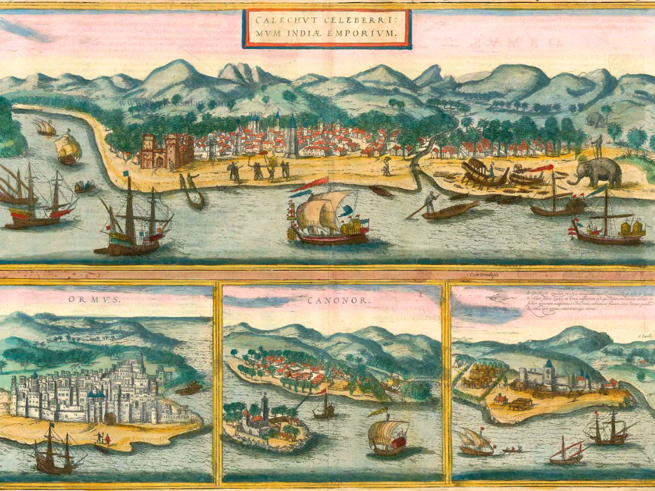
The strategic importance of the Strait of Hormuz has long been known, with numerous conflicts over its control throughout history. In 1507, Portuguese explorers captured the island of Hormuz and constructed a fortress. Here they created the first customs house to collect tolls for passage through the Strait.
The islands captured by the Portuguese were crucial to control over the Strait and they still retain their geopolitical power today despite their small size. Three of the eight islands in this region are highly disputed between Iran and the United Arab Emirates. Of the disputed islands, Abu Musā is the largest, with an area of 120 square kilometers and Lesser Tunb is the smallest, with an area of 12 square kilometers.
Portuguese colonists were eventually ousted in 1622 by an alliance between the Shah of Persia’s Safavid dynasty and the English East India Company. During this time and in the years after, the British would establish a presence in the Gulf, signing truces with seven sheikdoms which now make up the United Arab Emirates (UAE). Known as Trucial States, the British agreed to protect these sheikdoms from piracy in the Persian Gulf. In exchange, the Trucial States would conduct foreign relations solely with the British Empire.
The differing claims from Iran and the UAE are complex as they stem from the dynamics of the Qāsemi tribal confederacy, a nomadic group which sailed between the opposite shores of the Persian Gulf between 1747 and 1887. From Persia’s perspective, the Qāsemi were deputies of the Persian Government, settling and ruling Lengeh, an important port city on the northern shore of the Persian Gulf. The Sheik of Sharjah, now an Emirate of the UAE, was part of the Qāsemi in the lower gulf area and believed that Abu Musā was a hereditary tribal possession and that the Lengeh Qāsemi community managing the area was out of convenience, not a transfer of sovereignty. The Sheik of Ras al-Khaymah, also now part of the UAE, retained claims over the Greater and Lesser Tunbs in a similar fashion.
In 1887, Persia dissolved their Qāsemi deputy-governorship of Lengeh, opting instead to directly seize the port and plant the Persian flag on Sirri, one of the eight major islands just beyond the Strait of Hormuz. In the following year, it was reported that a Persian claim to Abu Musā appeared in a report prepared by the Persian military for the British prime minister which was not countered or objected to.
Disputes in the Modern Era
Oil was discovered in Iran in 1908, which led to the United Kingdom taking control of Abu Musā and the Greater and Lesser Tunbs. In 1933, the Anglo-Persian Oil company (now BP) got the favorable end of a deal to control Iran’s oil exports, granting most of the profits to the British. After roughly two decades of this relationship, the Iranian Prime Minister at the time, Mohammad Mossadegh, announced that Iran would be nationalizing its oil industry, which included the largest oil refinery in the world at the time. In response, the British sent the Royal Navy to establish a blockade at the port of Abadan, preventing Iranian oil tankers from passing through the Strait. Mossadegh was seen as a national hero to Iran in comparison to the Shah, who was frequently criticized for acting in the best interest of Western nations. In 1953, the British and United States cooperated on a CIA-backed coup to overthrow Mossadegh and reinstate the Shah, who agreed to split oil profits evenly between Iranian and Western oil companies.
In 1968, the United Kingdom announced they would be withdrawing all their forces from the Persian Gulf area by the end of 1971. To address the case of Abu Musā, a Memorandum of Understanding (MOU) was signed between Iran and the Sheik of Sharjah under which the parties agreed to divide jurisdictional control over the island without either side recognizing the sovereignty of the other. In this MOU, the States would also agree to the exploitation of petroleum resources and equal fishing rights in the 12 nautical mile territorial sea. The Sheik of Ras al-Khaymah however refused to negotiate the sovereignty of the Greater and Lesser Tunbs, stating that the islands are an integral part of their territory.
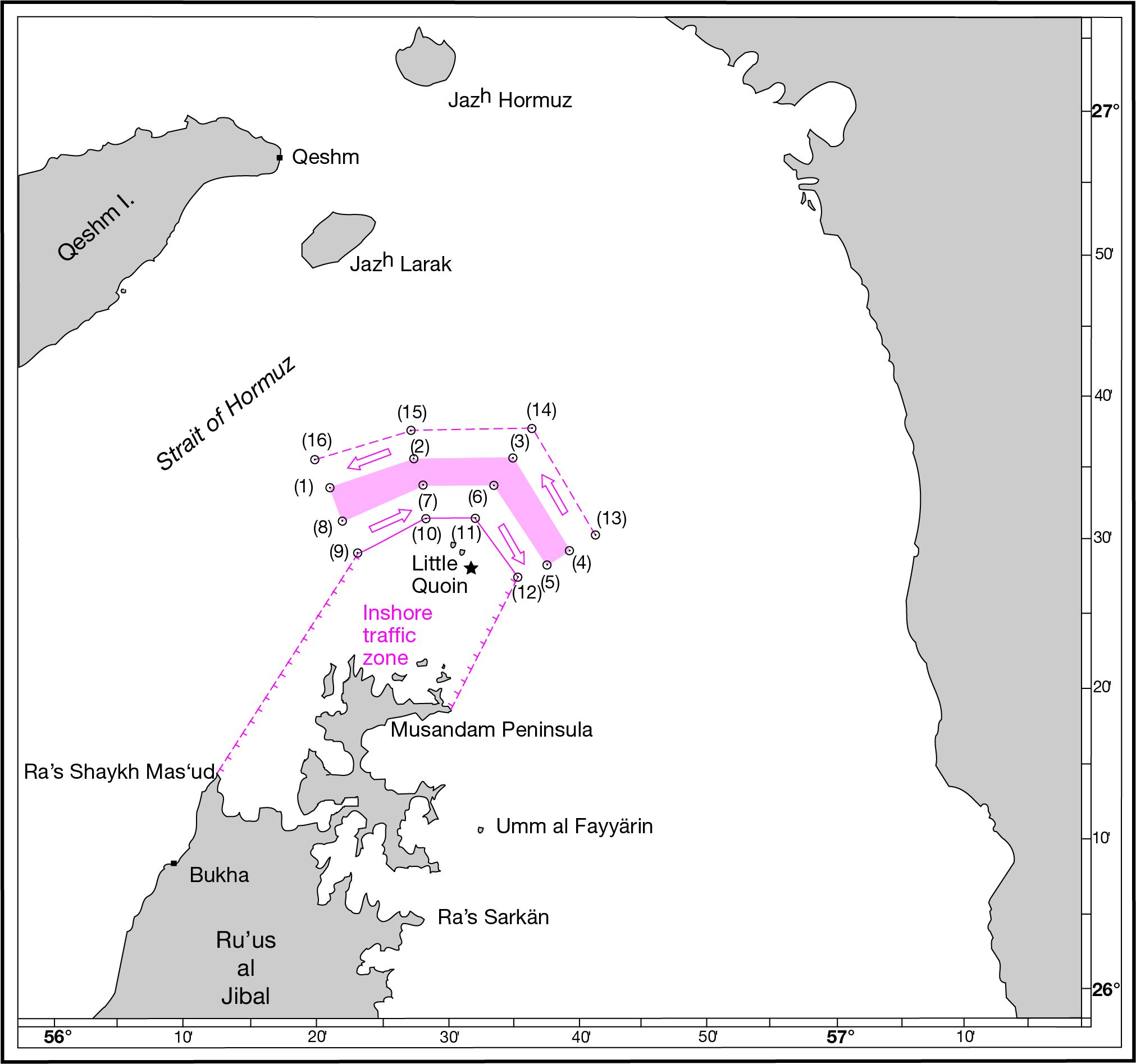
On 30 November 1971, the day prior to the departure of the forces of the United Kingdom, Iran resumed their presence on Abu Musā as specified in the Memorandum of Understanding while also seizing control over the Greater and Lesser Tunbs. The Sheiks accused the United Kingdom of colluding with Iran in their withdrawal, stating that they failed to protect their waters as dictated in their trucial agreements. To help ensure safe passage through the Strait in the following years, the United Nations established a Traffic Separation Scheme (TSS) in 1973. The TSS consists of two, two-nautical mile wide shipping lanes for incoming and outgoing traffic, respectively, with a one mile buffer zone in between them.
In addition to better-defined shipping channels, the entirety of the Gulf was in the process of being delimited by the littoral States. Bahrain and Saudi Arabia were the first States to delimit a maritime boundary in 1958, which occurred while UNCLOS I was being negotiated (https://legal.un.org/avl/ha/gclos/gclos.html). Maritime boundaries have now been established across much of the Gulf, with some areas of major dispute existing between Iran, Iraq and Kuwait as well as the Abu Musā and Tunb Islands. Even Iran and the UAE have a partially delimited maritime boundary, which was established by Iran and the Emirate of Dubai in 1974. For more information on Persian/Arabian Gulf maritime boundaries, please visit our Boundaries Pages.
In 1979, Ayatollah Ruhollah Khomeini and his clerics toppled the Shah’s regime, establishing the Islamic Republic of Iran. The invasion of Iran by Iraq in 1980 and the ensuing eight year war drastically altered diplomatic relations in the area, pitting most of the Gulf states against Iran. In April 1992, the regional Iranian military commander on Abu Musā prevented a group of non-Iranian laborers and teachers from entering the island, with a second similar instance occurring months later eventually turning into Iran’s complete consolidation of power over Abu Musā, though the 1971 MOU is technically still in effect.
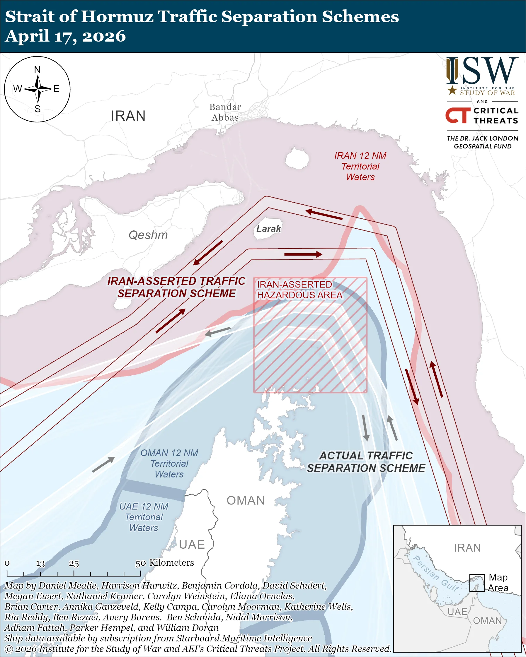
Iran’s control over the islands continues today and has lately been escalated through the use of underwater mines due to the ongoing conflict with the United States. Iran now has the ability to control who enters and leaves, functionally “closing” the Strait of Hormuz in March 2026 to “unfriendly nations.” A published map on 10 April 2026 illustrates new shipping lanes transiting vessels should utilize to avoid naval mines. The new map shows a Hazardous Area restricting all traffic over the traditionally used TSS lanes.
As of late Spring 2026, the Strait of Hormuz is still effectively closed due to the ongoing conflict between Iran and the United States. Restrictions on oil and gas exports continue, causing widespread economic and political ramifications across the globe as gas and oil prices increase in tandem with the length of time the Strait remains closed. Typically, the Strait provides free transit to over 100 ships per day. Since Iran’s closure, approximately six ships per day are being allowed through, with a number of vessels stranded at various points near the Strait of Hormuz awaiting safe passage.
Conclusion
The Strait of Hormuz is an incredibly important shipping route that the oil and gas industry, and therefore the broader global economy, depend on. Control of the narrow strait hinges on three very small, disputed islands, Abu Musā and the Greater and Lesser Tunbs. These islands have been de facto controlled by Iran since 1971, while the United Arab Emirates maintains an active claim to them. Iran has closed the Strait of Hormuz since the beginning of the conflict with the United States in March 2026, which has had global economic consequences. While there is a general desire from both the United States, Iran and the rest of the world to open the Strait of Hormuz as soon as possible, the dispute over Abu Musā and the Tunb Islands is unlikely to be resolved in the near future.