Author Archive

Sovereignty without Borders

January 13, 2025
IMA Research Team

By Zander Bamford-Brown

A look into disputes over the very meaning of sovereignty 

Nearly all the work we do at Sovereign Limits documenting international boundaries can be depicted by a few different kinds of lines on a map. We can illustrate contested boundaries and sovereignty disputes with a simple legend: a red dot for a disputed territory, a dashed line for a unilateral boundary claim and a solid line for an uncontested border. This is the visual expression of the current framework for international relations based on the Westphalian system. The Westphalian system serves as a common language through which key ideas like state, territory, borders and sovereignty have a universal meaning across the world. Through this shared language and set of principles, even sovereignty disputes can be discussed in a mutually intelligible manner. However, this is a limited viewpoint, and this post is about those places where the Westphalian system is not a shared language, where the people dispute the principles of this ideology and assert their own differing interpretations of sovereignty.

The Westphalian system was developed over the past three centuries and has come to replace most of the diversity in the organization of polities that had existed up until this point. The basic assertions of this system are that states have a monopoly on force within their territories and that states are the agents that conduct international relations. This amounts to a system of legally equal states with territorial integrity that are legitimized, in part, through mutual recognition. There is no room in this system for things other than territorial states to have sovereignty. Although some scholars argue we are now in a ‘Post-Westphalian’ system, its core components still remain central to international relations.

When this system was developed, primarily by Europeans in the late 18th century, it was quite a shift from many of the other models that had been used up until that point. For our work, the most important shift was the adoption of linear boundaries. Most European territories were not defined by linear boundaries until after the Napoleonic Wars ended in 1815 and even later in other parts of the world. This emphasis on linear cartographic boundaries, which had been developed during the European colonization of the Americas, has become a crucial component of the system. The Westphalian system views territory as the only legitimate source of sovereignty and that the only way to define territory is through linear boundaries. This concept is succinctly captured in a definition of Westphalian sovereignty by Stephen D. Krasner as “the ability of states to control movement across their borders.” It is the boundary, and control over that boundary, that makes a state sovereign.

The extent of cartographic understanding of the world shortly after the 1648 Peace of Westphalia. From the Library of Congress.

Despite the apparent universality of this system, which maps the political divisions of the world, the Westphalian system is generally understood to be a model. In reality, these principles have been regularly broken since the system was developed. One arena where this is visible is in the interactions between forms of sovereignty that predate the introduction of the Westphalian system by colonial forces. These forms of sovereignty, sometimes referred to as Indigenous sovereignty, are quite diverse but in general do not consider territory as the primary source of sovereignty. It is argued that these notions of sovereignty are incompatible with Westphalian sovereignty, giving rise to a class of sovereignty disputes and border regimes that cannot be explained fully within the Westphalian framework. 

Below I discuss how this interaction plays out between groups in two different Westphalian border areas: pastoralists along the Kenya-Uganda frontier and a Mohawk community along the Canada-United States international boundary. There are other similar disputes playing out around the world that affect both internal politics and international relations and these two cases highlight the diverse nature of these types of disputes.

The Karamoja Cluster and movement across the Kenya-Uganda border

Map showing the land boundary between Kenya and Uganda

For more about the Westphalian sovereignty of the Kenya–Uganda boundary, check out our Boundary Brief!

The Karamoja Cluster is a region that spans the northern portions of Kenya and Uganda, as well as parts of South Sudan and Ethiopia. The Cluster is very diverse and, to keep things simple, I am just looking at movement across the Kenya-Uganda border. Before British colonial forces came to East Africa and created what would become the modern-day countries of Kenya and Uganda, there were no strong centralized states. Instead, the primary political structure of the people in the region was the ethnic community. It was through the ethnic community that people built their governments and laid claim to territory, with some polities described as operating “almost at a comparable level with modern states.” While many of the groups in the Cluster claimed a bounded territory, the territory was not the legitimizing force behind political authority, and as these groups were pastoralists, the borders were more fluid. 

As one can imagine, the traditional borders of these pastoralist groups do not align with the British-made Kenya-Uganda frontier, and the international border today is often crossed during livestock raids and in search of pasture. A 2019 paper by a team of Kenyan researchers found that in the Kenyan-Ugandan border zone, the “traditional concept of borders—as defined by physical features and historical memories—still govern the movement of the pastoralists.” This movement is often necessary to keep herds alive in times of drought. A United Nations Development Programme (UNDP) brief even went as far as criticizing the “artificiality of state borders” as a constraint to pastoralism in the Karamoja Cluster and, by extension, the wellbeing of pastoralists.

The pastoralists in the Karamoja Cluster are not passive in this process; the UNDP brief emphasizes that the pastoralists have never accepted these national borders. Their continued use of traditional forms of security, governance and borders, as well as their resistance to this new form of sovereignty, are the primary reasons that “the nation-state still exists as an unaccomplished project in the [Kenya-Uganda border] zone.” Both the Kenyan and Ugandan governments, along with the British before them, have attempted to assert their sovereignty over this region. Yet the assertions have “yielded minimal results on the ground.” In short, though the people in this region are claimed as members of States, they have never been fully brought under its control. As pastoralists often disregard Westphalian borders and its notions of territoriality, their movements amount to an assertion of their own autonomy and sovereignty.  

Map of the Karamoja Cluster across South Sudan, Ethiopia, Kenya and Uganda. Cartography updated from Figure 1 in “Introducing pathways to resilience in the Karamoja Cluster.”

The most legible assertion of autonomy by these groups was a Peace Accord between the Turkana of Kenya and the Matheniko of Uganda. The 1978 Lokiriama Peace Accord put an end to what had become an uneven power relation in cattle raids following a ban by the Ugandan government on the carrying of weapons. These inter-group raids are a longstanding practice in the Cluster but have become increasingly deadly with the introduction of firearms and further incentivized by a growing commercial black market for cattle. In the signing of the Accord, the two groups conducted international affairs, something typically reserved for states in the Westphalian system. Both groups have since used their alliance to cross into the territory of the other and skirt restrictions imposed by either government. This directly undermines the sovereignty of these states and shows that the pastoralists had sufficient sovereignty to create an international agreement related to cross-border movement.

That being said, Kenya and Uganda still can and do assert their control over the border. A clear example of this is restricting people from entering their territory with weapons. In 2023, the Ugandan government passed an executive order banning Turkanans, one of the large pastoralist groups in Kenya, from entering Uganda with guns. Direct statements by the Turkana are hard to come by, but a quote by one Turkana elder in the wake of this new executive order may hint at their political position: “We want to be allowed back to Uganda to graze our animals, we were born pastoralists, and we have no borders, will die as a pastoralist not Ugandan or Kenyan.” In this statement the elder is refuting the right of the state not only to impose borders and control his movement but to claim him as a member of the nation, identifying instead as a ‘pastoralist’. For this elder, his movement across the international border is based on a political view that disputes not just the sovereignty of Kenya and Uganda, but the entire philosophy of Westphalian sovereignty and borders.  

The categorization of this situation is further complicated by the fact that the Kenyan and Ugandan governments have signed a Memorandum of Understanding (MoU) which allows for the free movement of unarmed people across the border. In some ways, this MoU formalizes the shared sovereignty between pastoralists and the Kenyan and Ugandan governments and brings their movements into the Westphalian system. With an open international border, the pastoralist groups can continue to assert their own boundaries, as they traditionally have done, without officially infringing on the sovereignty of the states. As scholars have concluded that neither government has been able to exert ‘supreme authority’ in the region or over the border for extended periods of time, it suggests that sovereignty is shared with the pastoralist groups of the Karamoja Cluster. 

The current situation along the Kenya-Uganda border makes the most essential question of our research difficult to answer: what are the sovereign limits of each country? How does one map two Westphalian states who claim contiguous areas but whose control on the ground is shared with groups who hold an incompatible form of sovereignty with ‘no borders’ or, at minimum, a different understanding of borders. Sometimes a written piece like this one is needed to express what a map cannot when Westphalian sovereignty is tenuous at best.

Akwesasne and nested sovereignty along the Canada–United States border

Map showing the land boundary between Canada and the US

For more about the established interantional boundary bewteen Canada and the United States, see our Boundary Brief.

The Mohawk community of Akwesasne, which is split by the Canada–United States international boundary, is another indigenous group experiencing conflict due to Westphalian sovereignty, but in a different context. The discussion of this border community serves as a complement to the Kenyan–Ugandan frontier because the sovereignty and border regime is marked by a much larger degree of direct government involvement. Together they show how Indigenous sovereignty can impact borders in a range of historical and political situations. 

As in the Karamoja Cluster, the assertion of Indigenous sovereignty in Akwesasne, the largest Mohawk community, creates a border regime that is not entirely in the control of the States. Akwesasne is divided into three reservations in different jurisdictions: Kawehno:ke (or Cornwall Island) in Ontario, an area in Quebec, and an adjacent area in the United States. Kawehno:ke is connected by bridges on either side to non-reservation land. The area in Quebec is cut off by rivers on two sides and only accessible by land from the United States. The part of Akwesasne in the United States is well connected to surrounding areas in the US.

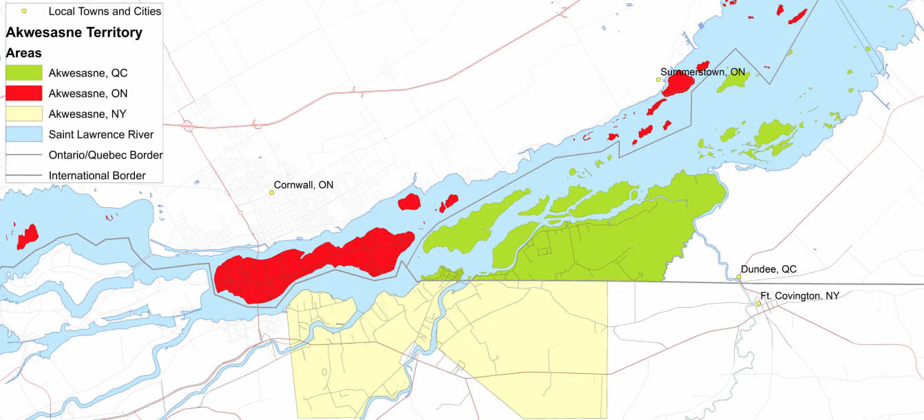
A map of the Akwesasne territory divided between two Canadian states (Quebec and Ontario) and New York, US, from Akwesasne Travel.

Between the US and the Quebec sections of Akwesasne, border control stations are conspicuously absent, allowing for an unimpeded flow of people across the otherwise well-regulated international boundary. A journalist visiting the area found himself struggling to keep track of how many times he crossed through what are termed ‘unstaffed road crossings.’ For someone traveling in Akwesasne, the Mohawk community could be seen to supersede Canada or the US, merging two distinct states into a single, non-Westphalian entity. 

This alone points to an atypical border regime but there is an example of an even clearer assertion of sovereignty by the Mohawk. In 2009, Canada implemented a national policy where border agents were required to carry guns. Mohawks in Akwesasne protested this policy change with the Chief saying

“[The Canada Border Service Agency] is a foreign oppressive force who occupies our sovereign community and territory. [They are] unwelcome, uninvited and now carrying firearms. For lack of a different description, that is considered by some an act of war.”

The night the policy went into effect, Mohawks gathered at the Canadian border station on the island in protest, and the agents stationed there left their posts. The station was never staffed again. After talks between Mohawk leaders and the Canadian government a new border crossing post was built beyond the reservation. That is, the Mohawk were able to assert their sovereignty over Kawehno:ke. Through their protest the Mohawk were able to deny the State the right to (1) carry weapons, and by extension use force, on their territory, and (2) effectively control the movement over their border. This is only made more salient by the Canadian government’s acceptance of these assertions, as shown through the construction of a new border post. 

Out of this process came a hard-to-categorize border situation between the United States and both portions of Akwesasne in Canada. When a person drives from the US to Kawehno:ke or Mohawk territory in Quebec, they enter Canada without going through border control. They could go shopping, stay a few nights with a friend, and return to the US without ever coming in contact with Canadian border services. If you didn’t know any better, you may think that you are only entering Mohawk territory and not Canada. An Akwesasne resident could grow up regularly crossing the border without ever having their movement controlled by the State. This community serves as an example of what some call ‘nested sovereignty,’ a product of the reservation system used in the US and Canada. Audra Simpson, a Mohawk scholar, argues that nested sovereignty “has implications for the sturdiness of nation-states” because the Westphalian system does not allow for overlapping sovereignty. One can see that clearly when the nested sovereignty crosses an international border.  

The example of the Kawehno:ke border crossing in many ways falls into the Westphalian system: it is a group (the Mohawk) asserting their sovereignty and monopoly on force in a bounded territory (a reservation). A crucial departure within the Westphalian framework is that the Mohawk are not internationally recognized as sovereign. Yet there is another departure, the political ideology of the Mohawk. Taiaiake Alfred, a Mohawk scholar, frames the issue of Indigenous struggles for autonomy as follows: “We already are sovereign in the philosophical sense, so to reorient ourselves in order to enter a form of relationship with a state, we have to sacrifice part of who we are.” Alfred sees the bases of Westphalian sovereignty as “abhorrent to an Indigenous philosophy and worldview.” But how can you map philosophical sovereignty? In order to retain some autonomy in the face of colonialism, Indigenous people in North America have, in some instances, chosen to engage on Westphalian terms. We can see this process through the Kawehno:ke border crossing and the reservation system as a whole. This process has taken place in the context of conversations in Indigenous communities about whether this is the right path for a group whose philosophy and sovereignty claims are based on an incompatible set of principles.

Much like in the Karamoja Cluster, the interactions between the Akwesasne community, Canada, and the United States have related to territorial boundaries and how to manage two irreconcilable notions of sovereignty. In both these cases, claims by Indigenous people of their own sovereignty has impacted cross border movement by limiting the role of the state in regulating it. These processes show how Indigenous assertions of sovereignty continue to impact border regimes in a variety of contexts and levels of state control, and how international relations and border regimes cannot be fully explained in the context of the Westphalian system nor solely on the basis of Indigenous sovereignty. 

The cases outlined here are part of a multifaceted history where contesting Westphalian sovereignty is as old as the system itself. The Westphalian system was created through interactions with Indigenous concepts of sovereignty and the continued interaction between the two may be a useful nexus to understand future developments in the system of international relations and borders. Lastly, it is important to give a voice to the people who have had their ability to access land, and through that their livelihood, curtailed through the colonial system and the Westphalian sovereignty that came with it. 

Belarus, Russia and what the heck is a Union State?

April 17, 2024
IMA Research Team

By Tyler Kruzshak & Marissa Wood

Introduction

Since the beginning of the current Russo–Ukrainian War in February 2022, Belarus has been given particular attention from Western audiences for its role as a Russian launching point in the full-scale invasion of Ukraine. Stemming from an increased visibility in international affairs, questions regarding the relationship between Russia and Belarus have become commonplace. Their contemporary relationship is largely based upon efforts made throughout the 1990s to establish what is known as the Union State of Russia and Belarus.

The Union State is a result of a roughly half-decade long process of developing agreements aimed toward reintegrating key facets of Russian and Belarusian security, economics and statecraft under a supranational state authority. Since its creation, this authority has been endowed with the responsibility to direct and ultimately homogenize the separate institutions of the respective members to establish a unified Belarusian–Russian State. It will be the purpose of this piece to surmise the origins of the Union State and its implications for sovereignty.

The End of the Soviet Union

The basis for support of the Union State in Belarus and Russia can be traced to the final months of the Soviet Union’s existence. Throughout 1991, the Soviet Union faced unprecedented political and economic chaos. It was proposed that the Soviet Union be politically and economically reoriented as a way of hoping to end such turmoil, an effort that Soviet citizens within Belarus and Russia both strongly supported.

A map of the Soviet Union from 1962 from the Library of Congress.

However, efforts to preserve the Soviet Union failed due to infighting within the Communist Party and the growing power of the various nationalist movements across the constituent countries. On 8 December 1991, the leaders of Belarus, Russia and Ukraine signed the Belovezha Accords, which officially declared the Soviet Union as dissolved and created the Commonwealth of Independent States (CIS). This was followed on 21 December 1991 by the Alma-Ata Protocol, signed by eleven of the former republics, which also declared the dissolution of the Soviet Union and expanded the membership of the CIS.

Belarus and Russia constituted two of the founding member States of the CIS, and they continued to maintain relatively close bilateral ties with one another. The particular historical context of the two countries as former Union Republics, as well as the tumultuous political, military and economic chaos of the 1990s, led Belarus and Russia to be inextricably incentivized to cooperate across a variety of issues with the aim of stabilizing the post-Soviet world. This range encapsulated such issues as aiding in market development and stabilization, maintaining security and limiting social strife.

Between 1992 and 1995, a contentious debate within Belarus developed regarding Belarus’s geopolitical orientation. Geographically located between Russia and the rest of Europe, Belarus occupied a particularly unique position wherein both Europe and Russia would vie for influence over the country. Supporters of furthering relations with Russia or reintegration occupied significant influence over the legislature, in addition to widespread popularity among the general population. Meanwhile, some Belarusian officials were adamant on a policy of neutrality towards Russia and the West, and an even smaller nationalist current were strongly supportive of European integration at the expense of relations with Russia. During this period, Belarus became increasingly economically dependent on Russia, reinforcing the pro-Russian political position. A multitude of treaties with Russia regarding economics, defense and security were signed during these years, and by 1995, following the 1994 victory of Alexander Lukashenko in the Belarussian Presidential Elections, Belarus began to pursue integration with Russia.

Russia also struggled with its own identity during this period, briefly flirting with diplomatic Westernization. However, by 1993, its focus had shifted to a much more assertive foreign policy of political and economic reintegration with post-Soviet countries through existing organizations such as the CIS, in addition to establishing new organizations, of which Belarus would play a central role. Belarus occupied a pivotal position in Russian military and security thought as the primary buffer between Russia and the rest of Europe. Military and nationalist leaders in Russia viewed Belarus as a vital historical and political ally for Russia.

A Multitude of “Union” Oriented Agreements

By the mid-1990s, Belarusian and Russian relations began to evolve much more rapidly. Both countries signed a series of agreements with the explicit aim to rekindle the economic and security ties between them. This section will give an overview of the agreements signed by the Parties throughout the 1990s and how they impacted international boundaries and security.

On 6 January 1995, Belarus and Russia agreed to form a bilateral customs union which primarily sought to develop a common economic zone. On 21 February 1995, the States signed the Treaty of Friendship, Good-Neighbourliness and Cooperation which established “mutual respect for state sovereignty and territorial integrity, [and the] inviolability of [their] borders.” The Agreement also established a framework for collaboration in economics, foreign policy and military strategy, as well as the establishment of a visa-free border regime.

Belarus also acted unilaterally to confirm its close relationship with Russia. In May 1995, Belarus held a referendum which addressed, among other things, whether Belarus should adopt Russian as a national language equal in status to Belarusian. The referendum also assessed interest in economic integration with Russia. Both measures passed overwhelmingly and set a legal precedent for the continuation of Belarusian–Russian relations.

A year later, in 1996, Belarus and Russia signed an agreement forming what they called the Association (sometimes translated as Community) between Belarus and Russia, which focused on further strengthening the economic ties of the two States. Each State continued to retain “its state sovereignty, independence and territorial integrity” but would collaborate on issues of foreign policy.

In 1997, Belarus and Russia signed the Treaty on the Union of Belarus and the Russian Federation, which continued the commitment of the States to further develop and integrate economic, social, political, security and legal matters. While this agreement called for the continued respect of each State’s sovereignty, it did note that the eventual goal was voluntary unification. Union citizenship was established, meaning citizens of either State were now legally considered citizens of both. Belarus and Russia also made efforts to establish a unified border policy and respond jointly to sovereignty threats and military developments.

By the late 1990s, the two countries appeared to be legally approaching a unique form of integration with one another. But in reality, Belarus and Russia were continuing to pursue individual goals, with their commitment to an eventual union wavering.

As the development of the Association reached completion, Belarus and Russia continued towards the goal of greater economic and security collaboration. In 1999, the two States signed the Treaty on the Establishment of the Union State, which reaffirmed the content of previous agreements but emphasized the “sovereign equality of the participating States,” with explicit reference to each country’s “independence [and] territorial integrity.”

To Unify or Not To Unify?

Since its establishment, the Union State has been most successful in the development of its security fields, despite many other stated purposes. The close relationship between Russia and Belarus on the security front has been tangibly observed by the presence of Russian military forces and infrastructure located on the border of Belarus during the initial escalation and continued violence with Ukraine.

Despite the military successes of the Union State, the economic and political aspects of integration have been more challenging, with trade wars and economic restrictions occurring between Russia and Belarus throughout the 2000s and 2010s. The political leaders of both countries, Vladimir Putin in Russia and Alexander Lukashenko in Belarus, viewed the Union State as an opportunity to expand their own political power. When this proved difficult, the importance of some aspects of the Union State faded away.

Furthermore, the future for the Union State as a territorial unit is largely uncertain. Despite various iterations aimed at voluntary territorial integration, both Russia and Belarus have sought to maintain their post-Soviet era borders and independence.

Belarus has played an important role in Russia’s territorial expansion into Ukraine, while preserving its own independence. Despite military cooperation between Belarus and Russia, it is unclear what the long term impact of decades of development towards economic and potential territorial integration will mean. Belarus and Russia continue to maintain good relations with one another, but the goals of its political leaders will likely have an outsized impact on the future potential of a fully unified Union State, maintenance of the current status quo or the creation of something else entirely.

Post-Soviet Maritime Boundary Delimitation in the Baltic Sea

December 5, 2023
IMA Research Team

By Alex Marsh

The Baltic Sea, despite being comparatively well-delimited relative to other bodies of water, remains an interesting case study in the novel application of maritime boundary law, as well the effect of historical and geopolitical tensions on boundary negotiation. Many of the complexities related to maritime boundary delimitation in the Baltic Sea can be traced to a 1988 Agreement between the Kingdom of Sweden and the Union of Soviet Socialist Republics (USSR), and the subsequent collapse of the USSR a few years later.

Sweden’s 1988 Agreement with the USSR established a multi-purpose boundary between the two party’s continental shelves and fishery zones. Crucially, this agreement did not apportion separate boundaries for each soviet satellite state in the Baltic region (Latvia, Lithuania, and Estonia, referred to hereafter as “the Baltic states”). Rather, the agreement created one boundary for the entirety of the USSR’s Baltic coast.

After the fall of the USSR in 1991, having regained their independence, the Baltic states argued that the maritime boundaries created for them by the USSR were not valid on the basis that the modern-day states of Latvia, Lithuania, and Estonia were not successors to the USSR member states of the same names, but to the preceding independent, pre-World War II republics. The Baltic states maintain they were illegally annexed by and incorporated into the USSR following World War II, and as such, international law should not treat boundaries negotiated by what was, in their view, an occupying power, as legitimate in light of their newfound independence.

Sweden (and to a lesser extent, Finland), maintained that the boundary negotiated with the USSR was valid and legitimate, a position strongly supported by the newly christened Russian Federation. Of note, the Russian Federation included language in their 2005 tripoint agreement with Lithuania and Sweden explicitly referring to the existence of the 1988 Agreement in support of this position. Sweden had no desire to renegotiate the existing boundary, which had resulted in a favorable resolution for Sweden, since it had taken a significant amount of time to agree upon the confines of the 1988 boundary due to disputes concerning fishery rights and the status of outlying islands between both parties.

Further complicating matters, the independence of the Baltic states necessitated the negotiation of bilateral maritime boundaries between those states, as well as tripoints where those new boundaries would inevitably intersect with existing boundaries, including the disputed Sweden–USSR boundary. With the Baltic states firmly against recognizing the Sweden–USSR boundary, and Sweden maintaining the boundary’s legitimacy, a workaround emerged that introduced a largely novel concept into the corpus (body) of international maritime law.

Typically, agreements creating or amending maritime boundaries are negotiated between the contracting parties by listing, at minimum, a set of coordinate points that make up the boundary, the method of connecting these points (i.e., a straight line, the arc of a great circle, etc..), and the datum used to list the coordinate points.

The Baltic states eschewed this procedure when negotiating tripoints with Sweden (specifically, the Sweden-Latvia-Lithuania and Sweden-Latvia-Estonia tripoints). Latvia negotiated bilateral agreements with Lithuania and Estonia, respectively, whose final points were not a defined coordinate. Instead, the agreement specified an azimuth along which the bilateral boundary would extend until encountering the maritime boundary of a “third state” (Sweden). By doing this, the Baltic states de facto recognized the existence of Sweden’s previously-defined maritime boundary without addressing the validity of the Sweden–USSR agreement, despite that agreement creating the same maritime boundary upon which the Latvia-Lithuania and Latvia-Estonia boundaries abut. The bilateral agreements and subsequent tripoint agreements between the Baltic states and Sweden do not make mention of the 1988 Sweden–USSR boundaries, with the Sweden-Latvia-Estonia tripoint agreement only listing a singular coordinate point to clarify the exact location of the tripoint. The Sweden-Lithuania-Russia tripoint, however, does note that the tripoint sits upon the historical 1988 Sweden–USSR boundary.

In another novel application of maritime boundary law, the entire maritime border between Sweden and Latvia does not appear to be explicitly acknowledged. Latvia’s bilateral agreements with Estonia and Lithuania use the aforementioned technique of specifying an azimuth which runs until encountering Sweden’s claimed maritime border. These two tripoints effectively serve as the de facto endpoints of the Sweden-Latvia maritime border, as no official agreement has been concluded between the two states, in part to avoid legitimizing the border drawn by the USSR. Even though Latvia is evidently content with the existing border on geographic and economic grounds, it is politically unfeasible for them to recognize a boundary drawn by the USSR, leading to the existing status quo. A bilateral agreement may eventually be concluded, but as of yet no efforts appear to have been made in this regard.

Ultimately, little changed in terms of the geographic location of the fateful 1988 Sweden–USSR boundary. Sweden prevailed in protecting the concessions it had gained during negotiations with the USSR, and maintained the boundary in its existing location. However, the Baltic states also largely prevailed in avoiding legitimizing the 1988 boundary. Bilateral and tripoint agreements exclusively between the Baltic states and Sweden used novel methods of delimitation to avoid acknowledgement of the 1988 border while still accomplishing (at least de facto) the delimitation of the new national boundaries in the area.

The Politics of Border Fences: Animal Edition

August 23, 2023
IMA Research Team

By Zander Bamford Brown

In the past few decades, the world has seen a dramatic increase in the construction of border walls and fences. Often, like in the case of the US-Mexico wall championed by Donald Trump, the barriers are built for political gain. As one analyst puts it: they benefit those in power because “they look great on television, they look strong and impenetrable, and it suggests to the viewer ‘We, the government, are protecting you from something.’” In the vast majority of cases, the ‘something’ the barriers are meant to protect against are people on the far side of the wall. It is widely understood that “nationalism is the central geopolitical fantasy that encourages, justifies and legitimates contemporary border walls.” There are, however, examples of border fences meant to prevent disease carrying animals from crossing between countries rather than humans. Examples of sanitary boundary fences can be observed in Botswana, Bulgaria, and Denmark.

Botswana built fences along two of its borders to prevent the spread of foot and mouth disease (FMD) among cattle, a socially and economically important animal for rural Batswana. FMD is a long standing issue in much of southern Africa that weakens cattle, and to stop its spread, Botswana built a fence on the Namibian border in 1996 and on the Zimbabwean border in the early 2000s. In Europe, the construction of sanitary fences was motivated by the 2014 spread of African swine fever (ASF). The disease is often contracted by contact between wild boar and domesticated pigs, and it kills almost every infected pig within 10 days. Bulgaria completed a fence to stop wild boars entering the country from Romania in 2018. Denmark then constructed a fence along the German border in 2019 to keep out wild boars and protect its $1.7 billion pork industry. 

Extensive agriculture along the border between Denmark and Germany. Imagery from Esri’s World Basemap, boundary data from Sovereign Limits.

On the surface these undertakings have “more to do with sanitation than geopolitics” (taken from a BBC description of the Botswana–Zimbabwe fence) and may be seen as operating in a distinct sphere from human-oriented border barriers. Without a doubt the sanitary concern in all three countries was very real, and the spread of disease had the potential to harm livestock and cripple local economies. However, there is a resounding lack of evidence proving the effectiveness of these sorts of fences. In fact, in all cases, it was known that infected animals would easily be able to circumvent the barrier. Why then did the governments choose to implement this unusual, costly, possibly ineffective, and environmentally damaging solution with a high risk of international backlash? The answer, though not clearcut, certainly involves politics. At the very least, these fences may be used to tell citizens that ‘the government is protecting you from disease and financial ruin’. Yet, the strikingly similar contexts under which all of these barriers were built suggests that these fences may be the product of a specific set of political circumstances. 

The sanitary fence on the border between Bulgaria and Romania. Image from Romania Journal.ro.
A sanitary fence on the borders of Botswana. Image from Cornell University.

A central component of this is the interplay between these fences and local perceptions of nationhood. Academics have found that these barriers, like fences meant to block humans, help draw a line between the nation and an ‘other’. An analysis of Danish border regulations for humans and pigs crossing the German border found that the two are woven together to help define the boundary of the nation and emphasize the worth of people and pigs that are viewed as Danish. These conclusions are echoed in a paper about the Botswana–Zimbabwe fence which determined that the barrier, though officially meant to keep out animals, may manifest “the desire to distinguish citizens of Botswana from ‘others’”. The ‘others’ are largely seen to be Zimbabweans, and Batswana officials have even admitted that the fence is unofficially meant to stop people from entering the country outside of official crossing points. In Bulgaria, no research has been done on the socio-political impact of the wild boar fence on the Romanian border. However, Bulgaria had previously built a fence along its border with Turkey to prevent asylum seekers and other migrants from entering the country. Research on this barrier found that it bolsters “nationalist, exclusionary visions of [the] political community.” This fence can be seen as part of a larger project to encourage xenophobia that has been ​​spearheaded by the state’s political elite. This suggests that the Bulgarian government had the understanding and motivation to use the Romanian fence to harden the line between Bulgarian and an ‘other’. While the justification for these fences may be apolitical, the end result is likely similar to human-oriented fences: to harden the conceptual boundaries of the nation.

These fences have only ever manifested under a specific set of political conditions: a threat of disease carried by animals, a sharp rise in anti-immigrant sentiment before the fence was built, and shared membership in an intergovernmental organization (IGO) on both sides of the fence. IGOs are entities involving multiple countries that are meant to work on issues of common interest. With the increase of globalization and the interdependence of nations, they have come to play a significant role in international politics. Furthermore all the IGOs in question encourage the free movement of people over their borders. Denmark, Germany, Bulgaria, and Romania are part of the European Union which considers borders between member states to be internal. Botswana, Namibia, and Zimbabwe are all in the Southern African Development Community (SADC) which promotes free movement of people between member states. It should be noted that despite their membership in the SADC, Botswana had tense relations with Zimbabwe and Namibia during the construction of the respective fences. 

All three countries also saw an uptick in anti-immigrant sentiment just before the construction of the sanitary fence. Denmark was once among “the most progressive in the world on asylum policy and refugee protection.” But the country saw a steep rise in anti-refugee sentiment in the 2010s, a shift clearly marked by the Prime Minister’s declaration that Denmark wanted ‘zero asylum seekers’ the same year the fence was constructed. A similar trend has been taking place in Bulgarian society, though the country was never known as particularly welcoming to refugees. In the years leading up to fence construction, xenophobia grew severe enough that the United Nations Human Rights Office expressed their concern about the situation. Botswana again stands out, this time because the government did not fan the anti-immigrant flames like the Danish and Bulgarian governments. Nevertheless, there has been a clear shift in opinion among Batswana. In the 1980s and early 90s Botswana was known as a “country of immigration”. Yet around the time the fence was constructed on the Namibian border, anti-immigrant sentiment began to rise, and six years later when the first fence posts were placed on the Zimbabwean border, surveys found that Batswana were ‘highly intolerant of outsiders’. 

Despite the official apolitical rationale for these fences, they only appear on relatively open borders where the governments and people have an antagonistic stance towards an ‘other’, whether it be the neighboring government or migrants. An argument could be made that these conditions encourage the construction of animal barriers. They can be seen as an attempt to manage the anti-other sentiment domestically while limiting backlash from an allied neighbor by providing a more neutral justification for its construction. Whether or not this can be proven, it would be extremely limiting to try to separate these fences from the political realities surrounding their construction. As border fences continue to be built and the COVID-19 pandemic has heightened awareness in the general public about the threat of spreading disease, these sorts of fences may become more common and have implications beyond their stated apolitical sanitations projects.

If you’re interested in learning more about other kinds of border fences, our friends at This American Life have a great story about “The Walls,” featuring a detailed interactive map made by us at International Mapping!

The North Sea Continental Shelf Cases

July 7, 2023
IMA Research Team

By Alex Marsh

Six states (the United Kingdom, France, Norway, Germany, the Netherlands, and Belgium) maintain continental shelf claims in the North Sea, a resource-rich and economically important body of water off the coast of western and northern Europe. Control of the continental shelf allows a State the exclusive rights to resource extraction from the seafloor, which is important in hydrocarbon rich regions such as the North Sea.

Figure 1. Established North Sea maritime boundaries.

Since the creation of the concept of a maritime boundary to divide marine natural resources, from fish to oil, delimitation disputes have been relatively common. Each country is incentivized to maximize their total claimed area in an effort to reap the most economic benefit. The North Sea Continental Shelf Cases (Denmark v. Germany & the Netherlands v. Germany) provide an interesting look at how supranational bodies like the International Court of Justice (ICJ) balance precedent, equity, and treaty obligations when resolving inter-state disputes apportioning maritime boundaries.

What was the dispute?

Germany’s continental shelf claims in the North Sea overlapped with those of the Netherlands and Denmark, since Germany measured their coastal baseline in a different manner than other states. The Netherlands and Denmark, located to the west and north of Germany, respectively, have convex coastlines, meaning their coastlines bulge outwards. Germany, on the other hand, has a concave North Sea coastline, meaning it dips inward. If the standard principle of equidistance was used to delimit the state’s continental shelf claims, Germany would end up being “squeezed in” and as a result be left with a smaller area of continental shelf.

Figure 2. Provisional equidistance lines in the North Sea.

With Germany’s preferred delimitation methodology differing so much from those of the Netherlands and Denmark, an area of disputed maritime territory arose. The Netherlands and Denmark wished to delimit the boundary according to the “C-D-E” and “A-B-E” lines in the map below, which are based on equidistance. On the contrary, Germany wished to delimit the boundary according to the “C-D-F” and “A-B-F” lines, arguing that a boundary based on equidistance from their concave coastline would deprive Germany of a continental shelf claim proportional to the size of their North Sea coastline.

Figure 3. Claim lines of Denmark, Germany, and the Netherlands.

Also at issue was the fact that, at the time, Germany was not party to the 1958 Convention on the Continental Shelf, while Denmark and the Netherlands were. The 1958 Convention calls for signatories to use the principle of equidistance when delimiting disputed continental shelf boundaries, which Denmark and the Netherlands wished to apply in this case. Denmark and the Netherlands argued that the 1958 Convention on the Continental Shelf, which specifically holds that such disputes should be resolved with the principle of equidistance, should be applied in this case. Having arrived at an impasse, Germany appealed to the ICJ to litigate the dispute. All states involved agreed to delimit their boundary according to the ruling of the Court. As such, they did not ask the Court to delimit the boundary, only to rule on the underlying assertion that Germany was bound by the 1958 Convention on the Continental Shelf.

The Decision

The ICJ first decided that Denmark’s and the Netherland’s originally separate cases against Germany should be joined, since they had a common interest. The Court held that Germany was not bound by the provisions of Article 6 of the 1958 Convention on the Continental Shelf because Germany was not a signatory to the agreement, and the convention was not yet a part of the “corpus” (body) of international law. Thus, Denmark and the Netherlands had no basis to compel Germany to delimit their disputed boundary via equidistance.

The Court stated that in order for a treaty to become a part of the “corpus” (body) of international law, states must have adhered extensively and almost universally to the principle in question. Furthermore, the Court held that the states in question must, in essence, feel that they are undertaking a legal obligation by adhering to the provisions of the treaty even if they haven’t signed it. The Court felt that, at the time of the case, neither the number of signatories to the 1958 convention (39 states) or the amount of time it was in force (11 years) suggested extensive or near universal adoption.

Lastly, the Court urged all the parties involved to mitigate the impact of “an incidental coastal feature” (Germany’s concave coastline) that could lead to an unjust apportionment of the continental shelf if the principle of equidistance is applied. As a result, Germany was granted most of the additional area they desired, which can be seen by comparing Figure 1 (current North Sea boundaries) to Figure 2 (equidistance). The three States were instructed by the Court to establish an equitable boundary, which was not necessarily based on equidistance but rather by a delimitation methodology agreed on by the states involved.

Impact

The Court ultimately found that equidistance was not, as claimed, a priori (customary) rule in international law. Rather, it was to be considered one delimitation option of many in the creation of equitable maritime boundaries. The Court also rejected Germany’s argument that apportionment should be done in such a way that the size of the continental shelf claim was proportional to a state’s coastline, as this would deny states the right to claim “the natural prolongation of their continental shelf.”

Instead, the Court proposed that delimitation should be done on the basis of “equitable principles,” taking multiple factors into account to ensure that each state was granted a fair portion of the contested claim. Following the Court’s ruling, Germany signed agreements with both Denmark and the Netherlands resolving their continental shelf dispute on January 28, 1971. Consequently, these agreements required the United Kingdom to adjust the endpoints of its continental shelf boundaries with Denmark and the Netherlands, which created a completely new continental shelf boundary with Germany, as the UK’s existing boundaries were based on the endpoints of the previous equidistance-based boundaries between Denmark and the Netherlands.

In all, the ICJ’s ruling in the North Sea Continental Shelf Cases (Federal Republic of Germany v. Netherlands & Federal Republic of Germany v. Denmark) was, and is, a significant ruling in international law because its findings relate to how conventions and agreements enter the corpus of the international legal framework. Equally significant was the Court’s holding that delimitation by equidistance was not necessarily customary in international law. Equidistance delimitation was, and is, still widely used, but the Court’s emphasis of equity over equidistance set a new precedent for boundary negotiations from 1969 onwards.

If you’re interested in learning more about the maritime boundaries delimited following the Court’s decision in North Sea Continental Shelf Cases check out our reports on the maritime boundaries of Germany–Netherlands and Denmark–Germany.

A Timeline of Control Over the Rafah Crossing Point

March 13, 2023
IMA Research Team

By Zander Bamford-Brown

Map showing the land boundary between Egypt and Gaza

The Rafah Crossing Point is the only official crossing for people between Egypt and the Palestinian territory of Gaza. The crossing is a lifeline for Gazans enduring the ongoing blockade by Israel and Egypt, and it is one of only two places where people can officially enter and exit the Gaza Strip. As with many aspects of the Israeli-Palestinian conflict, this crossing has a complex history. Below we have produced a timeline of the groups that have had direct control over this crossing. It is important to note that this timeline is a macro-scale view of the diplomatic relations surrounding the control of the official crossing. The reality for people, especially Palestinians in the Gaza Strip, is far more intricate. There are other official, unofficial, and illicit levels of control that impact the movement of people through this crossing. For example, while the Rafah border crossing was closed, a system of tunnels between Gaza and Egypt allowed goods and people to cross the border illegally. Conversely, even during the most open times there were significant border closures and individual restrictions imposed by Israel and Egypt on Gaza.

Zander wrote the code for this timeline as part of a class on the Geospatial Web at McGill University.

Background on the Gaza Strip and Palestine

The State of Palestine is a de jure state that has received recognition from a majority of United Nations member States. Palestine claims the discontiguous territories of the West Bank and the Gaza Strip. The Gaza Strip is a densely populated Palestinian exclave between southwestern Israel and Egypt. The area has a population of over 2 million, roughly two thirds of whom are registered refugees. Prior to 1948, the territories of Palestine and Israel were part of the British Mandate of Palestine. The mandate’s boundary with Egypt was based on a 1906 Treaty (see our Egypt Palestine (Gaza) Boundary Brief for a detailed description and analysis of the boundary). In 1949, Egypt took control of Gaza which it occupied until the 1967 Arab-Israeli War. Israel directly occupied Gaza from 1967 until 2005. In 2005 Israel ‘disengaged’ from Gaza, however, Israel has maintained significant control over Gaza’s borders and is still widely considered by the international community to be an occupying force.

The Rafah Border Crossing in 2012. Photo by Gigi Ibrahim – Flickr/Wikipedia.

The Palestinian Authority (PA) is the governing body that is tasked with the ‘municipal’ and internal affairs of Palestine. The PA has also come to take a role in representing Palestine internationally. Hamas is a militant Islamic Palestinian political party and organization. Hamas has been in control of Gaza since it won the PA legislative elections in 2006. In 2007 a violent conflict between Hamas and Fatah, the other large political party in the Palestinian legislature, led to Hamas gaining sole de facto control over Gaza while Fatah and the PA retained control of the West Bank. A handful of states, including Israel and the United States, consider Hamas to be a terrorist organization. Many other states consider Hamas’ military wing to be a terrorist organization.

A UN OCHA map of southwestern Gaza, including the location of the Rafah Crossing.

For more on the international boundary between Egypt and Palestine, check out our Boundary Brief.

Antarctica: Home to Ice, Penguins, and Boundary Disputes

November 29, 2022
IMA Research Team

By Alex Marsh

First discovered in 1840, Antarctica has long been the subject of intrigue in the international community. As the region’s ice continues to recede, increasing access to the area has prompted renewed scrutiny of states’ maritime and territorial claims.

Map from the 1933–1935 Second Byrd Antarctica Expedition, from the Library of Congress.

The Antarctic Treaty System

The Antarctic is unique in that it is the only continent on earth with no native human population, and therefore, no government. As interest in the region intensified in the mid-20th century, states recognized the need for international cooperation. As a result, Antarctica is governed by the Antarctic Treaty System, a collection of agreements and treaties that commits signatories to responsible and cooperative behavior in the region. The basis of the treaty system is a recognition by all states party to the treaty that, “it is in the interest of all mankind that Antarctica shall continue forever to be used exclusively for peaceful purposes and shall not become the scene or object of international discord.” As of 2022, 54 states are party to the Antarctic Treaty System, including all states which maintain territorial claims (or the right to assert a claim) in Antarctica.

The portion of the Antarctic Treaty System that concerns territorial claims and sovereignty is contained in the system’s founding document, the 1959 Antarctic Treaty. Despite the general spirit of cooperation in the Antarctic Treaty, Article 4 makes clear that those countries that had previously made territorial claims to Antarctica would not be renouncing them and that the agreement itself was in no way intended to establish any form of official recognition of any one countries claim.

Territorial Claims

A total of seven states have made land claims in Antarctica: France (Adélie Land), Argentina (Argentine Antarctica), Australia (Australian Antarctic Territory), the United Kingdom (British Antarctic Territory), Chile (Chilean Antarctic Territory), Norway (Peter I Island & Queen Maud Land), and New Zealand (Ross Dependency). These territorial claims are only recognized by the aforementioned seven states, and not unanimously. The United Kingdom, Argentina, and Chile have overlapping claims, and thus do not recognize each other’s claims. Land claims made by the seven states are conical in shape, extending outwards from the south pole to the Antarctic coast. The sole exception to this rule is the Norwegian claim, whose southern and northern limits remain undefined. The United States, Russia, Peru, and Uruguay have all reserved their right to make a claim, but as of 2022 have not done so.

The various claims to Antarctica.

Maritime Claims

Maritime claims in the Antarctic are the subject of some dispute. The United Nations Convention on the Law of the Sea (UNCLOS) and Antarctic Treaty System ostensibly clash in this area, with differing interpretations by different parties. Since the 1959 Antarctic Treaty only commits states to pausing “territorial” claims, some parties have argued it does not apply to maritime claims, or that it contradicts the rights of states to file extended continental shelf claims under Article 76 of UNCLOS. Historically, submissions to the Commission on the Limits of the Continental Shelf (CLCS) by states with territorial claims in the Antarctic explicitly requested that the CLCS not consider data from Antarctica, so as to avoid antagonizing parties to the Antarctic Treaty System by making new claims.

Australia, however, included their claimed “Australian Antarctic Territory” in their 2004 submission to the CLCS. The CLCS found that Australia’s claim was scientifically valid, delimiting not only the Australian Antarctic Territory’s ECS boundaries, but also claimed limits for a territorial sea and 200 nautical mile Exclusive Economic Zone. Argentina and Norway followed suit in 2009 with submissions to the CLCS that included their antarctic claims, and the United Kingdom and Chile have also declared their intent to file similar claims.

A map from Australia’s ECS submission depicting its EEZ and ECS claims to the Australian Antarctic Territory.

If you’re interested in learning more about the boundary weirdness of the extended continental shelf, check out this blog, which includes information on the claims of Antarctica’s polar opposite.

Research Outposts

While they are not a form of territorial claim, there are nonetheless a significant number of research outposts in Antarctica. There are 92 seasonal and full-time research stations in Antarctica, operated by 42 states (all members of the Antarctic Treaty System) and a total crew ranging anywhere between 1,000–4,000 scientists and researchers. The operation of a research station does not constitute a territorial claim under the Antarctic Treaty System, which states, “No acts or activities taking place while the present Treaty is in force shall constitute a basis for asserting, supporting or denying a claim to territorial sovereignty in Antarctica or create any rights of sovereignty in Antarctica.” As such, many states operate research outposts in territory claimed by other states with no issues. Scientific cooperation in the Antarctic is another principle of the Antarctic Treaty System, so the construction and operation of these outposts are not typically cause for dispute.

As the global climate continues to change, interest in the Antarctic is only expected to increase. Numerous states that have reserved their right to make territorial claims have begun seriously examining the possibility, while others, such as Australia, test the boundaries of the Antarctic Treaty System’s constraints on sovereignty claims. The Antarctic will continue to be an area of global interest, territorial dispute, and scientific research.

More to Maritime Boundaries: The Extended Continental Shelf

February 4, 2022
IMA Research Team

By: Alex Marsh

Extended continental shelf (ECS) claims have become increasingly important to coastal states due to emerging technology and a changing climate that has opened new possibilities for resource extraction, but what exactly are these far out maritime features?

“Normal” continental shelf claims as defined in Article 76 of the 1982 United Nations Convention on the Law of the Sea (UNCLOS) are “the seabed and subsoil of the submarine areas that extend beyond [a coastal state’s] territorial sea throughout the natural prolongation of its land territory to the outer edge of the continental margin, or to a distance of 200 nautical miles from the baselines from which the breadth of the territorial sea is measured…” In other words, the continental shelf is the natural extension of a state’s landmass into the ocean, at a maximum distance of 200 nautical miles (M) from a state’s claimed baselines.

But there are many areas where the geography of the continental shelf extends beyond 200 M, and in these places, coastal states can submit an extended continental shelf claim for an area up to 350 nautical miles from their baselines if it can be proven that this area is still a natural extension of their land territory.

Continental shelf claims are valuable because of the rights they grant coastal states over the claimed area. Articles 77 and 81 of UNCLOS establish that a state entitled to an area of continental shelf retains the exclusive right to explore and exploit the natural resources located on or in the shelf. These rights extend to mineral/non-living resources as well as seabed organisms. Coastal states are not, however, granted sovereignty over the sea or airspace above a continental shelf entitlement.

If a state believes it is entitled to an area of continental shelf beyond 200 M, it will submit data and information supporting its claim to the Commission on the Limits of the Continental Shelf (CLCS), a UN body composed of scientific experts responsible for adjudicating extended continental shelf claims. After consideration of the submission, the CLCS will then issue a binding recommendation on the scientific validity of the state’s claim.

There are many scenarios where more than one state will lay claim to the same area of extended continental shelf. When this occurs, the states will submit their supporting data to the CLCS, who will then provide a recommendation on the validity of each state’s continental shelf claim. The CLCS does not, however, set the boundary between the two states but may only provide a recommendation on whether each state’s claim is scientifically valid. It is then up to the various claimants to negotiate an ECS boundary.

Coastal states have 10 years from the date they ratified UNCLOS to submit extended continental shelf claims. For example, Canada ratified UNCLOS in 2003, and needed to submit any extended continental shelf claims to the CLCS by 2013. A state may then later amend or supplement submissions. Canada deposited its initial ECS claims for the Atlantic Ocean in 2013 and added an area of Arctic Ocean ECS in 2019. States that are not signatories to UNCLOS, such as the United States, are unable to submit extended continental shelf claims to the CLCS, but they do still have ECS claims. The United States is currently working on its extended continental shelf claim.

Extended continental shelf claims involving only one state are typically non-controversial if they are deemed scientifically valid. For example, the area of high sea known as the “Peanut Hole” in the Sea of Okhotsk was declared part of the Russian continental shelf by the CLCS in 2014 without much fanfare.

Map from Russia’s non-controversial ECS claim in the “Peanut Hole”/Sea of Okhotsk, submitted to the CLCS in 2013.

Notable extended continental shelf claims in recent years have primarily involved areas of overlapping claims. Overlapping claims naturally receive more attention and can take far longer to resolve. Denmark (Faroe Islands), Norway (including Jan Mayen), and Iceland recently ratified agreements to delimit their extended continental shelf entitlements in an area of the Norwegian Sea known as the “Banana Hole.” All three states submitted their supporting information to the CLCS with the understanding that once it was confirmed that their claims were scientifically valid, they would establish boundaries according to a preliminary trilateral agreement negotiated in 2006 and made official in 2019 after the decision of the CLCS.

In three separate bilateral agreements in 2019, Denmark (on behalf of the Faroe Islands), Iceland, and Norway agreed to the delimitation of their ECS boundaries in the “banana hole.” This map is from Norway’s publication of their agreement with Denmark.

Another example of overlapping claims can be observed in the marine Ontong Java Plateau, located in the southern Pacific Ocean. Micronesia, Papua New Guinea, and the Solomon Islands all have overlapping continental shelf claims in the area. Since all three small island states believe they are entitled to a portion of the area, they decided to pool their time and resources to make a joint submission to the CLCS to establish the outer limits of their overlapping claim rather than submit competing claims for portions of the plateau. Once the CLCS establishes the outer limits of the “claimable” area, the area will belong to all three states jointly until they choose to begin trilateral negotiations to delimit boundaries.

Map from the joint submission by the Federated States of Micronesia, Papua New Guinea and the Solomon Islands to the CLCS in 2009.

Perhaps the most prominent area of overlapping ECS claim are those in the Arctic Ocean. As climate change makes the region more accessible to economic activity, arctic coastal states are acting with increased urgency to ensure their access to large deposits of natural resources underneath the melting icecap. Canada, Denmark, Norway, and Russia have all made overlapping claims in the region, and the United States is working towards publishing its ECS claim in the disputed waters.

Canada, Denmark, Norway, and Russia have all made overlapping ECS claims in the Arctic Ocean. The United States will likely also lay claim to the disputed waters in the near future.

The extended continental shelf is very much the next frontier of maritime boundary delimitation as technology improves to allow for coastal states to exploit the distant continental shelf resources, climate change makes portions of the ECS more accessible, and the global reliance on fossil fuels leads to interest in extracting hydrocarbon resources from novel locations.

The “Quadripoint” Area

June 20, 2021
IMA Research Team

By Zander Bamford-Brown

The Kazungula Bridge, as if out of a fairytale, crosses the Zambezi River in a place that does not exist, at least not according to most maps. It is not in some remote mountainous area nor is it a unimportant bridge; it is the sole border crossing between Botswana and Zambia. Their border, nestled between Namibia and Zimbabwe on the Zambezi River, is the shortest in the world. It is so short that it can’t be depicted on smaller scale maps. 

An oblique perspective of the completed Kazungula Bridge taken from a plane leaving a Namibian airport. Image from Wikipedia.

Instead of depicting the Botswana–Zambia border, maps will instead show a single point where the countries of Botswana, Namibia, Zambia, and Zimbabwe allegedly meet. This has led to the border being called a ‘quadripoint area,’ because it is currently the closest thing on earth to a quadripoint international boundary (where four countries meet). Though many maps, and the term quadripoint area, negate the presence of the Botswana–Zambia border, it does in fact exist.

A map of the Quadripoint Area. The bridge, which was under construction at the time of this imagery, has now been completed.

The 135 meters (443 feet) of river, just enough to fit the Kazungula Bridge, creates an economic block, disrupting trade between Zimbabwe and Namibia. Any travel between the two nations must first go through another country. Conversely, the Kazungula Bridge allows free trade between Zambia and Botswana. This has been a matter of contention for Zimbabwe. Before the construction of the bridge, most Botswana–Zambia trade was moved through Zimbabwe and was taxed by the government. The construction of the bridge, which was completed during the COVID-19 pandemic and opened in May 2021, once both nations reopened their border, means that Zimbabwe will lose that revenue. However, since the boundary is not a true quadripoint, Zimbabwe does not have the power to stop two nations from building a bridge over their shared border. 

For more information on the five international boundaries that meet at the “Quadripoint,” check out our Boundaries pages:

Botswana–Namibia, Botswana–Zambia, Botswana–Zimbabwe, Namibia–Zambia, and Zambia–Zimbabwe.

A Brief History of Point Roberts

May 28, 2021
IMA Research Team

And a Few Other Canada–United States Boundary Oddities

By Marissa Wood & Harrison Boyle

This blog was created using ArcGIS StoryMaps, and for the best viewing experience, we recommend visiting this page.

Twitter Facebook Linked In YouTube
Subscribe to our newsletter (and receive a free map!) SUBSCRIBE